|
| at: |
Brawley Mountain |
Data from David Muse
 show on map
 animate

There's another FS45 near the Ocoee Whitewater Center in Tennessee.
Trail users:


Elevation Profile
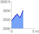
 2.464433 mi
 854.38 ft
 260.88 ft
 593.50 ft
 6.57 %
GPX Downloads: Track Route