| at: |
Chestatee WMA |
Data from David Muse
 show on map
 animate
Trail users:


Elevation Profile
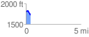
 0.410531 mi
 22.04 ft
 100.60 ft
 -78.55 ft
 4.64 %
GPX Downloads: Track Route
![]()
| at: |
Chestatee WMA |
show on map
animate
0.410531 mi
22.04 ft
100.60 ft
-78.55 ft
4.64 %