| at: |
Chestatee WMA |
Data from David Muse
 show on map
 animate
Trail users:


Elevation Profile
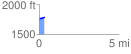
 0.334144 mi
 36.27 ft
 0.00 ft
 36.27 ft
 2.06 %
GPX Downloads: Track Route
![]()
| at: |
Chestatee WMA |
show on map
animate
0.334144 mi
36.27 ft
0.00 ft
36.27 ft
2.06 %