| at: |
Chattahoochee WMA/Mark Trail Wilderness |
Data from David Muse
 show on map
 animate
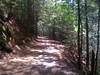
This trails mostly follows an old Byrd-Matthews logging rail.
Trail users:
Elevation Profile
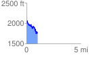
 1.012259 mi
 259.78 ft
 520.08 ft
 -260.30 ft
 9.73 %
GPX Downloads: Track Route