| at: |
Iron Mountain/Sumac Creek |
Data from Positive Flow
 show on map
 animate
Trail users:


Elevation Profile
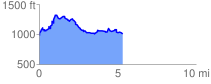
 5.368601 mi
 861.63 ft
 844.79 ft
 16.83 ft
 3.04 %
GPX Downloads: Track Route
![]()
| at: |
Iron Mountain/Sumac Creek |
show on map
animate
5.368601 mi
861.63 ft
844.79 ft
16.83 ft
3.04 %