| at: |
Iron Mountain/Sumac Creek |
Data from David Muse
 show on map
 animate
Trail users:


Elevation Profile
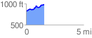
 1.587960 mi
 212.47 ft
 55.44 ft
 157.03 ft
 2.53 %
GPX Downloads: Track Route
![]()
| at: |
Iron Mountain/Sumac Creek |
show on map
animate
1.587960 mi
212.47 ft
55.44 ft
157.03 ft
2.53 %