| at: |
Harbison State Forest |
Data from Positive Flow
 show on map
 animate
Trail users:


Elevation Profile
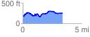
 3.375508 mi
 436.64 ft
 370.22 ft
 66.42 ft
 2.45 %
GPX Downloads: Track Route
Trailheads:
 Midlands Mountain Trailhead
![]()
| at: |
Harbison State Forest |
show on map
animate
3.375508 mi
436.64 ft
370.22 ft
66.42 ft
2.45 %
Midlands Mountain Trailhead