| at: |
Mount Ogden Park |
Data from Jason Sager
 show on map
 animate
Trail users:


Elevation Profile
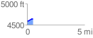
 0.505404 mi
 56.87 ft
 17.43 ft
 39.44 ft
 2.13 %
GPX Downloads: Track Route
![]()
| at: |
Mount Ogden Park |
show on map
animate
0.505404 mi
56.87 ft
17.43 ft
39.44 ft
2.13 %