| at: |
Cheaha State Park |
Data from David Muse
 show on map
 animate
Trail users:


Elevation Profile
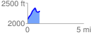
 1.084947 mi
 310.95 ft
 100.47 ft
 210.48 ft
 5.43 %
GPX Downloads: Track Route
![]()
| at: |
Cheaha State Park |
show on map
animate
1.084947 mi
310.95 ft
100.47 ft
210.48 ft
5.43 %