| at: |
West Rim |
Data from Positive Flow
 show on map
 animate
Trail users:


Elevation Profile
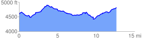
 12.712124 mi
 2190.85 ft
 1962.05 ft
 228.80 ft
 3.26 %
GPX Downloads: Track Route
Trailheads:
 McDonald CreekRabbit Valley Trailhead
![]()
| at: |
West Rim |
show on map
animate
12.712124 mi
2190.85 ft
1962.05 ft
228.80 ft
3.26 %
McDonald CreekRabbit Valley Trailhead