| at: |
West Georgia Pinhoti Johns Mountain WMA |
Data from USFS GIS
 show on map
 animate
Trail users:


Elevation Profile
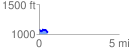
 0.539835 mi
 49.32 ft
 99.86 ft
 -50.54 ft
 3.50 %
GPX Downloads: Track Route
![]()
| at: |
West Georgia Pinhoti Johns Mountain WMA |
show on map
animate
0.539835 mi
49.32 ft
99.86 ft
-50.54 ft
3.50 %