|
| at: |
Houston Valley |
Data from USFS GIS
 show on map
 animate
Trail users:


Elevation Profile
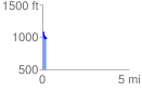
 0.229243 mi
 27.72 ft
 138.75 ft
 -111.02 ft
 11.46 %
GPX Downloads: Track Route
![]()
|
| at: |
Houston Valley |
show on map
animate
0.229243 mi
27.72 ft
138.75 ft
-111.02 ft
11.46 %