|
| at: |
Houston Valley |
Data from USFS GIS
 show on map
 animate
Trail users:


Elevation Profile
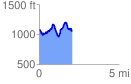
 2.080634 mi
 703.27 ft
 720.88 ft
 -17.61 ft
 6.56 %
GPX Downloads: Track Route
![]()
|
| at: |
Houston Valley |
show on map
animate
2.080634 mi
703.27 ft
720.88 ft
-17.61 ft
6.56 %