| at: |
Johns Mountain WMA The Pocket |
Data from USFS GIS
 show on map
 animate
Trail users:

Elevation Profile
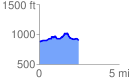
 2.595978 mi
 1308.27 ft
 1308.27 ft
 0.00 ft
 9.54 %
GPX Downloads: Track Route
![]()
| at: |
Johns Mountain WMA The Pocket |
show on map
animate
2.595978 mi
1308.27 ft
1308.27 ft
0.00 ft
9.54 %