| at: |
Johns Mountain WMA |
Data from USFS GIS
 show on map
 animate
Trail users:

Elevation Profile
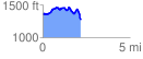
 2.176204 mi
 457.70 ft
 538.70 ft
 -81.00 ft
 4.69 %
GPX Downloads: Track Route
![]()
| at: |
Johns Mountain WMA |
show on map
animate
2.176204 mi
457.70 ft
538.70 ft
-81.00 ft
4.69 %