|
| at: |
Houston Valley |
Data from USFS GIS
 show on map
 animate
USFS GIS data shows this as an inventoried trail, named xxx and not designated as open to any particular traffic.
Trail users:
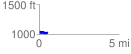
Elevation Profile
 0.515123 mi
 161.93 ft
 168.49 ft
 -6.56 ft
 6.19 %
GPX Downloads: Track Route