| at: |
Tray Mountain |
Data from USFS GIS
 show on map
 animate
Trail users:

Elevation Profile
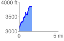
 1.676805 mi
 965.38 ft
 227.55 ft
 737.83 ft
 10.90 %
GPX Downloads: Track Route
![]()
| at: |
Tray Mountain |
show on map
animate
1.676805 mi
965.38 ft
227.55 ft
737.83 ft
10.90 %