| at: |
Tray Mountain Swallow Creek WMA |
Data from USFS GIS
 show on map
 animate
Trail users:

Elevation Profile
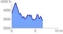
 6.769712 mi
 2434.36 ft
 2950.21 ft
 -515.85 ft
 8.25 %
GPX Downloads: Track Route
![]()
| at: |
Tray Mountain Swallow Creek WMA |
show on map
animate
6.769712 mi
2434.36 ft
2950.21 ft
-515.85 ft
8.25 %