|
| at: |
Beasley Knob |
Data from USFS GIS
 show on map
 animate
Trail users:


Elevation Profile
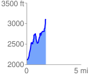
 1.756144 mi
 1331.60 ft
 318.18 ft
 1013.42 ft
 14.36 %
GPX Downloads: Track Route
![]()
|
| at: |
Beasley Knob |
show on map
animate
1.756144 mi
1331.60 ft
318.18 ft
1013.42 ft
14.36 %