|
| at: |
Beasley Knob |
Data from USFS GIS
 show on map
 animate
Trail users:


Elevation Profile
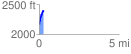
 0.286988 mi
 242.75 ft
 7.67 ft
 235.07 ft
 16.02 %
GPX Downloads: Track Route
![]()
|
| at: |
Beasley Knob |
show on map
animate
0.286988 mi
242.75 ft
7.67 ft
235.07 ft
16.02 %