| at: |
Coopers Creek WMA |
Data from USFS GIS
 show on map
 animate
Trail users:

Elevation Profile
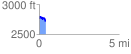
 0.409765 mi
 90.01 ft
 135.32 ft
 -45.31 ft
 6.25 %
GPX Downloads: Track Route
![]()
| at: |
Coopers Creek WMA |
show on map
animate
0.409765 mi
90.01 ft
135.32 ft
-45.31 ft
6.25 %