| at: |
Gumlog Mountain/Brasstown Bald |
Data from USFS GIS
 show on map
 animate
Trail users:

Elevation Profile
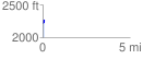
 0.091217 mi
 59.03 ft
 13.87 ft
 45.16 ft
 12.26 %
GPX Downloads: Track Route
![]()
| at: |
Gumlog Mountain/Brasstown Bald |
show on map
animate
0.091217 mi
59.03 ft
13.87 ft
45.16 ft
12.26 %