| at: |
Tray Mountain |
Data from David Muse
 show on map
 animate
Trail users:

Elevation Profile
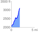
 1.805374 mi
 1179.67 ft
 139.17 ft
 1040.49 ft
 12.38 %
GPX Downloads: Track Route
Trailheads:
 Andrews Cove Camp Ground
![]()
| at: |
Tray Mountain |
show on map
animate
1.805374 mi
1179.67 ft
139.17 ft
1040.49 ft
12.38 %
Andrews Cove Camp Ground