| at: |
Panther Creek |
Data from USFS GIS
 show on map
 animate
Trail users:

Elevation Profile
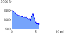
 5.825627 mi
 3321.69 ft
 4066.10 ft
 -744.41 ft
 13.22 %
GPX Downloads: Track Route
![]()
| at: |
Panther Creek |
show on map
animate
5.825627 mi
3321.69 ft
4066.10 ft
-744.41 ft
13.22 %