| at: |
Iron Mountain/Sumac Creek |
Data from USFS GIS
 show on map
 animate
Trail users:

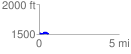
Elevation Profile
 0.571407 mi
 83.67 ft
 90.98 ft
 -7.30 ft
 3.02 %
GPX Downloads: Track Route
![]()
| at: |
Iron Mountain/Sumac Creek |
show on map
animate
0.571407 mi
83.67 ft
90.98 ft
-7.30 ft
3.02 %