| at: |
Rich Mountain |
Data from USFS GIS
 show on map
 animate
Trail users:

Elevation Profile
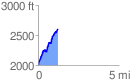
 1.212888 mi
 680.36 ft
 82.15 ft
 598.21 ft
 10.62 %
GPX Downloads: Track Route
![]()
| at: |
Rich Mountain |
show on map
animate
1.212888 mi
680.36 ft
82.15 ft
598.21 ft
10.62 %