| at: |
Rich Mountain |
Data from USFS GIS
 show on map
 animate
Trail users:

Elevation Profile
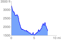
 8.136271 mi
 1529.20 ft
 2993.30 ft
 -1464.10 ft
 6.97 %
GPX Downloads: Track Route
![]()
| at: |
Rich Mountain |
show on map
animate
8.136271 mi
1529.20 ft
2993.30 ft
-1464.10 ft
6.97 %