| at: |
Brawley Mountain |
Data from USFS GIS
 show on map
 animate
Trail users:

Elevation Profile
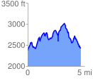
 4.717017 mi
 1608.10 ft
 1569.12 ft
 38.98 ft
 6.46 %
GPX Downloads: Track Route
![]()
| at: |
Brawley Mountain |
show on map
animate
4.717017 mi
1608.10 ft
1569.12 ft
38.98 ft
6.46 %