| at: |
Coopers Creek WMA |
Data from USFS GIS
 show on map
 animate
Trail users:

Elevation Profile
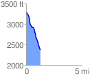
 1.288268 mi
 20.68 ft
 920.23 ft
 -899.55 ft
 13.53 %
GPX Downloads: Track Route
![]()
| at: |
Coopers Creek WMA |
show on map
animate
1.288268 mi
20.68 ft
920.23 ft
-899.55 ft
13.53 %