| at: |
Coopers Creek WMA |
Data from USFS GIS
 show on map
 animate
Trail users:

Elevation Profile
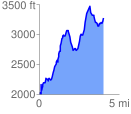
 4.003747 mi
 2321.68 ft
 1056.50 ft
 1265.18 ft
 10.98 %
GPX Downloads: Track Route
![]()
| at: |
Coopers Creek WMA |
show on map
animate
4.003747 mi
2321.68 ft
1056.50 ft
1265.18 ft
10.98 %