| at: |
Iron Mountain/Sumac Creek |
Data from Positive Flow
 show on map
 animate
Trail users:


Elevation Profile
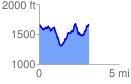
 3.136186 mi
 950.88 ft
 914.64 ft
 36.24 ft
 5.74 %
GPX Downloads: Track Route
![]()
| at: |
Iron Mountain/Sumac Creek |
show on map
animate
3.136186 mi
950.88 ft
914.64 ft
36.24 ft
5.74 %