| at: |
Iron Mountain/Sumac Creek |
Data from Positive Flow
 show on map
 animate
Trail users:


Elevation Profile
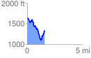
 1.582323 mi
 393.18 ft
 690.55 ft
 -297.37 ft
 8.27 %
GPX Downloads: Track Route
![]()
| at: |
Iron Mountain/Sumac Creek |
show on map
animate
1.582323 mi
393.18 ft
690.55 ft
-297.37 ft
8.27 %