| at: |
South Oconee National Forest |
Data from USFS GIS
 show on map
 animate
Trail users:

Elevation Profile
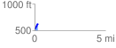
 0.248963 mi
 98.94 ft
 5.63 ft
 93.31 ft
 7.53 %
GPX Downloads: Track Route
![]()
| at: |
South Oconee National Forest |
show on map
animate
0.248963 mi
98.94 ft
5.63 ft
93.31 ft
7.53 %