| at: |
Piedmont National Wildlife Refuge |
Data from USFS GIS
 show on map
 animate
Trail users:

Elevation Profile
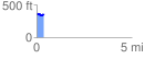
 0.368795 mi
 45.05 ft
 54.48 ft
 -9.44 ft
 2.80 %
GPX Downloads: Track Route
![]()
| at: |
Piedmont National Wildlife Refuge |
show on map
animate
0.368795 mi
45.05 ft
54.48 ft
-9.44 ft
2.80 %