| at: |
North Oconee National Forest |
Data from USFS GIS
 show on map
 animate
Trail users:


Elevation Profile
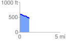
 1.208341 mi
 26.90 ft
 173.58 ft
 -146.67 ft
 2.72 %
GPX Downloads: Track Route
![]()
| at: |
North Oconee National Forest |
show on map
animate
1.208341 mi
26.90 ft
173.58 ft
-146.67 ft
2.72 %