| at: |
North Oconee National Forest |
Data from USFS GIS
 show on map
 animate
Trail users:


Elevation Profile
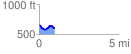
 0.980488 mi
 93.73 ft
 138.28 ft
 -44.55 ft
 2.67 %
GPX Downloads: Track Route
![]()
| at: |
North Oconee National Forest |
show on map
animate
0.980488 mi
93.73 ft
138.28 ft
-44.55 ft
2.67 %