| at: |
Coopers Creek WMA |
Data from USFS GIS
 show on map
 animate
Trail users:

Elevation Profile
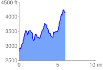
 6.048153 mi
 3030.10 ft
 1663.14 ft
 1366.95 ft
 9.49 %
GPX Downloads: Track Route
Trailheads:
 Wolfpen Gap
![]()
| at: |
Coopers Creek WMA |
show on map
animate
6.048153 mi
3030.10 ft
1663.14 ft
1366.95 ft
9.49 %
Wolfpen Gap