| at: |
South Oconee National Forest |
Data from USFS GIS
 show on map
 animate
Trail users:


Elevation Profile
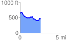
 2.544729 mi
 333.35 ft
 493.29 ft
 -159.94 ft
 3.67 %
GPX Downloads: Track Route
![]()
| at: |
South Oconee National Forest |
show on map
animate
2.544729 mi
333.35 ft
493.29 ft
-159.94 ft
3.67 %