| at: |
South Oconee National Forest |
Data from USFS GIS
 show on map
 animate
Trail users:


Elevation Profile
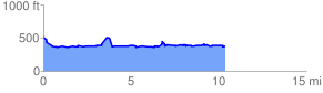
 10.490232 mi
 1170.31 ft
 1322.60 ft
 -152.29 ft
 2.39 %
GPX Downloads: Track Route
![]()
| at: |
South Oconee National Forest |
show on map
animate
10.490232 mi
1170.31 ft
1322.60 ft
-152.29 ft
2.39 %