| at: |
South Oconee National Forest |
Data from USFS GIS
 show on map
 animate
Trail users:


Elevation Profile
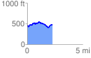
 2.281939 mi
 313.98 ft
 312.36 ft
 1.63 ft
 2.61 %
GPX Downloads: Track Route
![]()
| at: |
South Oconee National Forest |
show on map
animate
2.281939 mi
313.98 ft
312.36 ft
1.63 ft
2.61 %