| at: |
North Oconee National Forest |
Data from USFS GIS
 show on map
 animate
Trail users:


Elevation Profile
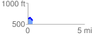
 0.419772 mi
 37.05 ft
 81.18 ft
 -44.13 ft
 3.66 %
GPX Downloads: Track Route
![]()
| at: |
North Oconee National Forest |
show on map
animate
0.419772 mi
37.05 ft
81.18 ft
-44.13 ft
3.66 %