| at: |
South Oconee National Forest |
Data from USFS GIS
 show on map
 animate
Trail users:


Elevation Profile
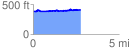
 2.814859 mi
 372.37 ft
 347.22 ft
 25.15 ft
 2.51 %
GPX Downloads: Track Route
![]()
| at: |
South Oconee National Forest |
show on map
animate
2.814859 mi
372.37 ft
347.22 ft
25.15 ft
2.51 %