| at: |
Coleman River Scenic Area |
Data from USFS GIS
 show on map
 animate
Trail users:

Elevation Profile
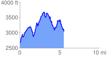
 5.803572 mi
 2658.49 ft
 2313.79 ft
 344.70 ft
 8.68 %
GPX Downloads: Track Route
![]()
| at: |
Coleman River Scenic Area |
show on map
animate
5.803572 mi
2658.49 ft
2313.79 ft
344.70 ft
8.68 %