| at: |
Swallow Creek WMA |
Data from USFS GIS
 show on map
 animate
Trail users:

Elevation Profile
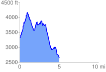
 5.138120 mi
 1774.11 ft
 2450.39 ft
 -676.28 ft
 9.03 %
GPX Downloads: Track Route
![]()
| at: |
Swallow Creek WMA |
show on map
animate
5.138120 mi
1774.11 ft
2450.39 ft
-676.28 ft
9.03 %