| at: |
Sandy Ford |
Data from USFS GIS
 show on map
 animate
Trail users:

Elevation Profile
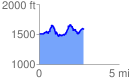
 2.856969 mi
 738.65 ft
 636.85 ft
 101.80 ft
 4.90 %
GPX Downloads: Track Route
![]()
| at: |
Sandy Ford |
show on map
animate
2.856969 mi
738.65 ft
636.85 ft
101.80 ft
4.90 %