| at: |
Warwoman WMA |
Data from USFS GIS
 show on map
 animate
Trail users:

Elevation Profile
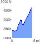
 4.083974 mi
 2261.82 ft
 994.94 ft
 1266.88 ft
 10.49 %
GPX Downloads: Track Route
![]()
| at: |
Warwoman WMA |
show on map
animate
4.083974 mi
2261.82 ft
994.94 ft
1266.88 ft
10.49 %