| at: |
Sandy Ford |
Data from USFS GIS
 show on map
 animate
Trail users:

Elevation Profile
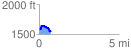
 0.731589 mi
 173.16 ft
 223.31 ft
 -50.15 ft
 5.78 %
GPX Downloads: Track Route
![]()
| at: |
Sandy Ford |
show on map
animate
0.731589 mi
173.16 ft
223.31 ft
-50.15 ft
5.78 %