| at: |
Warwoman WMA |
Data from USFS GIS
 show on map
 animate
Trail users:

Elevation Profile
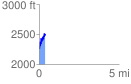
 0.436958 mi
 360.10 ft
 130.74 ft
 229.36 ft
 15.61 %
GPX Downloads: Track Route
![]()
| at: |
Warwoman WMA |
show on map
animate
0.436958 mi
360.10 ft
130.74 ft
229.36 ft
15.61 %