| at: |
Warwoman WMA |
Data from USFS GIS
 show on map
 animate
Trail users:


Elevation Profile
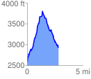
 2.822916 mi
 1318.95 ft
 966.32 ft
 352.63 ft
 8.85 %
GPX Downloads: Track Route
![]()
| at: |
Warwoman WMA |
show on map
animate
2.822916 mi
1318.95 ft
966.32 ft
352.63 ft
8.85 %