| at: |
Sandy Ford |
Data from USFS GIS
 show on map
 animate
Trail users:

Elevation Profile
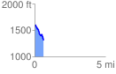
 0.628076 mi
 80.60 ft
 351.32 ft
 -270.73 ft
 10.59 %
GPX Downloads: Track Route
![]()
| at: |
Sandy Ford |
show on map
animate
0.628076 mi
80.60 ft
351.32 ft
-270.73 ft
10.59 %